File:Topographic map of Liberia-en.svg

Size of this PNG preview of this SVG file: 799 × 600 pixels. Other resolution: 320 × 240 pixels.
Original file (SVG file, nominally 3,148 × 2,363 pixels, file size: 1.69 MB)
Summary
| Description |
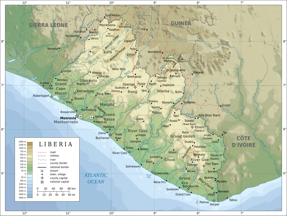
English: Topographic map of Liberia.
Français : Carte topographique du Liberia.
Suomi: Liberian topografinen kartta. |
| Date | |
| Source |
Self-made in Inkscape. Boundaries, rivers, roads, railroads, and place names based on a public domain United Nations map (Image:Un-liberia.png). Topography based on public domain GLOBE data from NOAA (http://www.ngdc.noaa.gov/mgg/topo/gltiles.html). Relief shading is an embedded PNG raster, derived from the GLOBE data using Perl. Bathymetry from NGDC ETOPO2. |
| Author | Oona Räisänen (Mysid) |
| Other versions |
Derivative works of this file: Railways in liberia-de.svg
|


| This SVG file contains embedded text that can be translated into your language, using any capable SVG editor, text editor or the SVG Translate tool. For more information see: About translating SVG files. |
Licensing
I, the copyright holder of this work, hereby publish it under the following licenses:

|
Permission is granted to copy, distribute and/or modify this document under the terms of the GNU Free Documentation License, Version 1.2 or any later version published by the Free Software Foundation; with no Invariant Sections, no Front-Cover Texts, and no Back-Cover Texts. A copy of the license is included in the section entitled GNU Free Documentation License. |
This file is licensed under the Creative Commons Attribution-Share Alike 4.0 International, 3.0 Unported, 2.5 Generic, 2.0 Generic and 1.0 Generic license.
- You are free:
- to share – to copy, distribute and transmit the work
- to remix – to adapt the work
- Under the following conditions:
- attribution – You must give appropriate credit, provide a link to the license, and indicate if changes were made. You may do so in any reasonable manner, but not in any way that suggests the licensor endorses you or your use.
- share alike – If you remix, transform, or build upon the material, you must distribute your contributions under the same or compatible license as the original.
You may select the license of your choice.
File history
Click on a date/time to view the file as it appeared at that time.
| Date/Time | Thumbnail | Dimensions | User | Comment | |
|---|---|---|---|---|---|
| current | 20:08, 31 July 2010 | | 3,148 × 2,363 (1.69 MB) | Mysid | remove the false "dropoff" from land to sea in shading |
File usage
The following page links to this file:
