File:Sydney Harbour Bridge night.jpg

Size of this preview: 800 × 200 pixels. Other resolutions: 320 × 80 pixels | 13,742 × 3,431 pixels.
Original file (13,742 × 3,431 pixels, file size: 10.9 MB, MIME type: image/jpeg)
Summary
| Description |
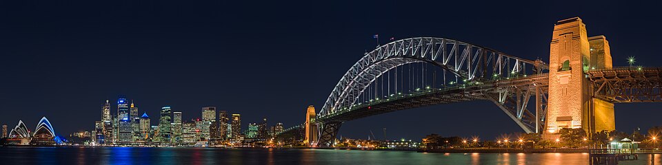
English: A panoramic view of the Sydney Harbour Bridge at night, as seen from the North Shore suburb of Kirribilli.
Français : Le Harbour Bridge vu depuis Kirribilli, une commune de la banlieue de Sydney sur la rive nord.
中文:从克里比利北岸拍摄的悉尼港大桥。 |
| Date | Taken on 15 June 2005 |
| Source | taken by Diliff |
| Author | Diliff |
| Permission (Reusing this file) |
Summary:In using this image or any subsequent derivatives of it, you are required to release the image under the same license. As such, any reproduction of this image, in any medium, must appear with a copy of, or full URL of the license.Attribution of this image to the author (DAVID ILIFF) is also required, preferably in a prominent location near the image.No other conditions may be added to, or removed from this license without the permission of the author and copyright holder.Suggested attribution: "Photo by DAVID ILIFF. License: https://creativecommons.org/licenses/by-sa/3.0/"Please review the full license requirements carefully before using this image. If you would like to clarify the terms of the license or negotiate less restrictive commercial licensing outside of the bounds of GFDL/CC-BY-SA, please contact me by email, or if you don't have a Wikipedia account you can either leave a message on my talk page with your contact details and your request, or you can contact me on Facebook. Please also send a 'friend request' to ensure that I am aware of your message. |
| Other versions |
copied from en.wikipedia |
| Camera location | | View this and other nearby images on: OpenStreetMap |
|---|
Licensing
I, the copyright holder of this work, hereby publish it under the following licenses:
This file is licensed under the Creative Commons Attribution-Share Alike 3.0 Unported license.
- You are free:
- to share – to copy, distribute and transmit the work
- to remix – to adapt the work
- Under the following conditions:
- attribution – You must give appropriate credit, provide a link to the license, and indicate if changes were made. You may do so in any reasonable manner, but not in any way that suggests the licensor endorses you or your use.
- share alike – If you remix, transform, or build upon the material, you must distribute your contributions under the same or compatible license as the original.

|
Permission is granted to copy, distribute and/or modify this document under the terms of the GNU Free Documentation License, Version 1.2 or any later version published by the Free Software Foundation; with no Invariant Sections, no Front-Cover Texts, and no Back-Cover Texts. A copy of the license is included in the section entitled GNU Free Documentation License. |
You may select the license of your choice.
Assessment
|

This image was selected as picture of the day on Wikimedia Commons for 5 October 2006. It was captioned as follows: English: Sydney Harbour Bridge Other languages:
Cymraeg: Pont Harbwr Sydney Deutsch: Hafenbrücke in Sydney English: Sydney Harbour Bridge Español: Puente del puerto de Sídney, Australia. Magyar: A Sydney Harbour-híd Norsk nynorsk: Sydney Harbour Bridge Polski: Most portowy w Sydney (Harbour Bridge) Português: Ponte do porto de Sydney Slovenščina: Sydneyjski pristaniški most Svenska: Sydney Harbour Bridge Русский: Мост в гавани (Harbour Bridge), Сидней 中文: 悉尼港大桥 العربية : جسر ميناء مدينة سيدني |
| Annotations | This image is annotated: View the annotations at Commons |
File history
Click on a date/time to view the file as it appeared at that time.
| Date/Time | Thumbnail | Dimensions | User | Comment | |
|---|---|---|---|---|---|
| current | 14:03, 19 June 2013 | 13,742 × 3,431 (10.9 MB) | Diliff | reprocessed... different colour balance, slightly wider view. |
File usage
The following page links to this file:
