File:Namibia regions WV map.png

Size of this preview: 616 × 600 pixels. Other resolutions: 246 × 240 pixels | 1,500 × 1,461 pixels.
Original file (1,500 × 1,461 pixels, file size: 615 KB, MIME type: image/png)
Summary
| Description |
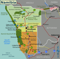
English: Regions of Namibia plus its major cities, roads and railroads (Wikivoyage regional scheme), English version |
| Date | |
| Source | Derivative work of File:Map-Namibia03.png and the Namibia map from the Perry-Castañeda Library Map Collection |
| Author | NJR ZA (original) and Shaundd (updates) |
| Other versions |
Licensing
This file is licensed under the Creative Commons Attribution-Share Alike 3.0 Unported license.
- You are free:
- to share – to copy, distribute and transmit the work
- to remix – to adapt the work
- Under the following conditions:
- attribution – You must give appropriate credit, provide a link to the license, and indicate if changes were made. You may do so in any reasonable manner, but not in any way that suggests the licensor endorses you or your use.
- share alike – If you remix, transform, or build upon the material, you must distribute your contributions under the same or compatible license as the original.
File history
Click on a date/time to view the file as it appeared at that time.
| Date/Time | Thumbnail | Dimensions | User | Comment | |
|---|---|---|---|---|---|
| current | 20:58, 16 March 2013 | | 1,500 × 1,461 (615 KB) | Shaundd | User created page with UploadWizard |
File usage
The following page links to this file:
