File:MexicoCityMap.PNG

Size of this preview: 485 × 599 pixels. Other resolutions: 194 × 240 pixels | 612 × 756 pixels.
Original file (612 × 756 pixels, file size: 159 KB, MIME type: image/png)
Summary
| Description |
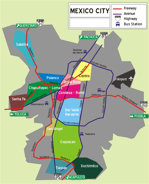
English: Mexico City Map, with District Layout as represented in Wikivoyage. Not necessarily a Geopolitical representation. Urbanized area appears in Gray and is only an approximation. |
| Date | 16 April 2007 (original upload date) |
| Source | Own work |
| Author | (WT-en) Fabz at English Wikivoyage |
Licensing
(WT-en) Fabz at en.wikivoyage-old.org, the copyright holder of this work, hereby publishes it under the following license:
This file is licensed under the Creative Commons Attribution-Share Alike 1.0 Generic license.
Attribution: (WT-en) Fabz at en.wikivoyage-old.org
- You are free:
- to share – to copy, distribute and transmit the work
- to remix – to adapt the work
- Under the following conditions:
- attribution – You must give appropriate credit, provide a link to the license, and indicate if changes were made. You may do so in any reasonable manner, but not in any way that suggests the licensor endorses you or your use.
- share alike – If you alter, transform, or build upon this work, you must distribute the resulting work under the same license as the original.
Original upload log
| This file was imported from Wikivoyage en. |
The original description page was here. All following user names refer to en.wikivoyage-old.
- 2012-09-14 21:36 Atsirlin 612×756 (163145 bytes) cleanup
- 2007-04-16 00:45 Atsirlin 612×756 (138177 bytes) Mexico City Map, with District Layout as represented in Wikitravel. Not necessarily a Geopolitical representation. Urbanized area appears in Gra (Import from wikitravel.org/en)
File history
Click on a date/time to view the file as it appeared at that time.
| Date/Time | Thumbnail | Dimensions | User | Comment | |
|---|---|---|---|---|---|
| current | 09:35, 4 January 2013 | | 612 × 756 (159 KB) | MGA73bot2 | {{BotMoveToCommons|en.oldwikivoyage|year={{subst:CURRENTYEAR}}|month={{subst:CURRENTMONTHNAME}}|day={{subst:CURRENTDAY}}}} == {{int:filedesc}} == {{Information |description=Mexico City Map, with District Layout as represented in Wikivoyage. Not necessa... |
File usage
The following page links to this file:
