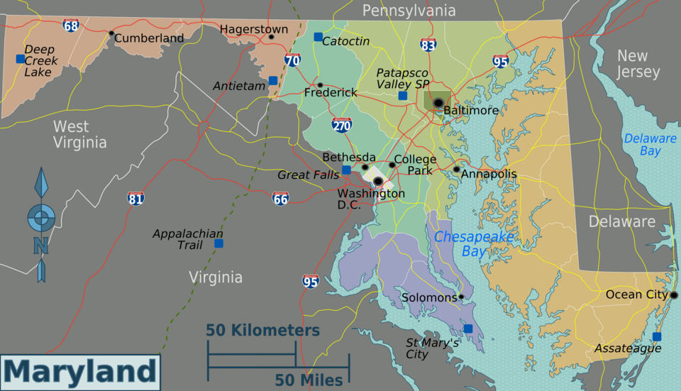
File:Maryland regions map.png

Size of this preview: 800 × 460 pixels. Other resolutions: 320 × 184 pixels | 3,008 × 1,728 pixels.
Original file (3,008 × 1,728 pixels, file size: 1.42 MB, MIME type: image/png)
Summary
| Description | Maryland regions map for use on Wikivoyage, English version |
| Date | |
| Source | Own work based on the US Geo survey map, map of Maryland, and map of Virginia |
| Author | Peter Fitzgerald |
| Other versions | SVG base file |
Licensing
| This work has been released into the public domain by its author, User: (WT-shared) Peterfitzgerald at wts wikivoyage. This applies worldwide. In some countries this may not be legally possible; if so: User: (WT-shared) Peterfitzgerald at wts wikivoyage grants anyone the right to use this work for any purpose, without any conditions, unless such conditions are required by law.
|
Original upload log
| This file was imported from Wikivoyage WTS. |
The original description page was here. All following user names refer to wts.wikivoyage-old.
- 2008-03-06 04:13 (WT-shared) Peterfitzgerald archive copy at the Wayback Machine 2473×1350 (246225 bytes) {{Imagecredit|credit=Peter Fitzgerald|captureDate=5 March 2008|location=Maryland|source=[[:Image:Maryland regions map.svg]]|caption=Maryland (Import from wikitravel.org/shared)
- 2008-03-07 00:41 (WT-shared) Peterfitzgerald archive copy at the Wayback Machine 2473×1350 (247316 bytes) move Cecil Co. to Eastern Shore (Import from wikitravel.org/shared)
- 2008-03-14 17:15 (WT-shared) Peterfitzgerald archive copy at the Wayback Machine 2472×1349 (305983 bytes) make DC more distinct color, add cities markers for the 9 (Import from wikitravel.org/shared)
- 2008-09-10 15:43 (WT-shared) Peterfitzgerald archive copy at the Wayback Machine 3008×1731 (1335367 bytes) overhaul, mos (Import from wikitravel.org/shared)
- 2009-03-29 07:36 (WT-shared) Peterfitzgerald archive copy at the Wayback Machine 3008×1728 (1491581 bytes) improved (hopefully) aesthetics (Import from wikitravel.org/shared)
File history
Click on a date/time to view the file as it appeared at that time.
| Date/Time | Thumbnail | Dimensions | User | Comment | |
|---|---|---|---|---|---|
| current | 14:01, 29 November 2012 | | 3,008 × 1,728 (1.42 MB) | OgreBot | (BOT): Reverting to most recent version before archival |
File usage
The following 7 pages link to this file:
