File:Louisiana regions map.png

Size of this preview: 667 × 600 pixels. Other resolutions: 267 × 240 pixels | 1,024 × 921 pixels.
Original file (1,024 × 921 pixels, file size: 313 KB, MIME type: image/png)

|
File:Louisiana regions map.svg is a vector version of this file. It should be used in place of this PNG file.
File:Louisiana regions map.png → File:Louisiana regions map.svg
For more information, see Help:SVG. |
 |
Summary
| Description |
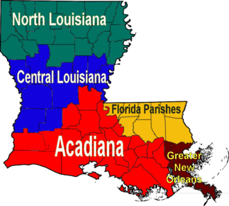
English: Map of Louisiana's regions (English) Français : Une carte des régions de la Louisiane (Anglais) |
| Date | (UTC) |
| Source | Based on Image:Map of Louisiana highlighting Jefferson Davis Parish.svg, colors filled in based on data from University of Louisiana at Lafayette Center for Cultural and Eco-Tourism |
| Author | Sherool |
| Other versions |
|
Licensing
| I, the copyright holder of this work, release this work into the public domain. This applies worldwide. In some countries this may not be legally possible; if so: I grant anyone the right to use this work for any purpose, without any conditions, unless such conditions are required by law. |
| Annotations | This image is annotated: View the annotations at Commons |
File history
Click on a date/time to view the file as it appeared at that time.
| Date/Time | Thumbnail | Dimensions | User | Comment | |
|---|---|---|---|---|---|
| current | 16:43, 2 December 2006 | | 1,024 × 921 (313 KB) | Sherool | {{Information |Description=Map over Louisiana's regions |Source=Based on Image:Map of Louisiana highlighting Jefferson Davis Parish.svg, colors filled in based on data from [http://ccet.louisiana.edu/03a_Cultural_Tourism_Files/01.00_The_Land.html Uni |
File usage
The following page links to this file:
