File:Idaho regions map.png

Size of this preview: 388 × 599 pixels. Other resolutions: 155 × 240 pixels | 1,106 × 1,707 pixels.
Original file (1,106 × 1,707 pixels, file size: 617 KB, MIME type: image/png)

|
This file was moved to Wikimedia Commons from wts.oldwikivoyage using a bot script. All source information is still present. It requires review. Additionally, there may be errors in any or all of the information fields; information on this file should not be considered reliable and the file should not be used until it has been reviewed and any needed corrections have been made. Once the review has been completed, this template should be removed. For details about this file, see below. Check now! |
Summary
| Description |
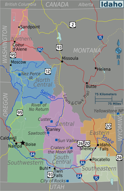
English: Idaho regions map. English version, Idaho
|
| Date | |
| Source | :Image:Idaho regions map.svg |
| Author | Peter Fitzgerald, :wmc:User:25or6to4 |
Licensing

|
Permission is granted to copy, distribute and/or modify this document under the terms of the GNU Free Documentation License, Version 1.2 or any later version published by the Free Software Foundation; with no Invariant Sections, no Front-Cover Texts, and no Back-Cover Texts. A copy of the license is included in the section entitled GNU Free Documentation License. |
This file is licensed under the Creative Commons Attribution-Share Alike 4.0 International, 3.0 Unported, 2.5 Generic, 2.0 Generic and 1.0 Generic license.
- You are free:
- to share – to copy, distribute and transmit the work
- to remix – to adapt the work
- Under the following conditions:
- attribution – You must give appropriate credit, provide a link to the license, and indicate if changes were made. You may do so in any reasonable manner, but not in any way that suggests the licensor endorses you or your use.
- share alike – If you remix, transform, or build upon the material, you must distribute your contributions under the same or compatible license as the original.
Original upload log
| This file was imported from Wikivoyage WTS. |
The original description page was here. All following user names refer to wts.wikivoyage-old.
- 2009-06-09 09:54 (WT-shared) Peterfitzgerald archive copy at the Wayback Machine 1106×1707 (632229 bytes) {{Imagecredit|credit=Peter Fitzgerald, [[:wmc:User:25or6to4]]|captureDate=9 June 2009|location=Idaho|source=[[:Image:Idaho regions map.svg]] (Import from wikitravel.org/shared)
File history
Click on a date/time to view the file as it appeared at that time.
| Date/Time | Thumbnail | Dimensions | User | Comment | |
|---|---|---|---|---|---|
| current | 00:07, 18 November 2012 | | 1,106 × 1,707 (617 KB) | MGA73bot2 | {{BotMoveToCommons|wts.oldwikivoyage|year={{subst:CURRENTYEAR}}|month={{subst:CURRENTMONTHNAME}}|day={{subst:CURRENTDAY}}}} == {{int:filedesc}} == {{Information |description=Idaho regions map. English version, Idaho * Map of: Idaho¤ |date=9 June 2009 ... |
File usage
The following page links to this file:
