File:Czech Rep. - Bohemia, Moravia and Silesia III (en).png
Size of this preview: 800 × 454 pixels. Other resolutions: 320 × 182 pixels | 3,852 × 2,188 pixels.
Original file (3,852 × 2,188 pixels, file size: 1.11 MB, MIME type: image/png)

|
This historical map image could be re-created using vector graphics as an SVG file. This has several advantages; see Commons:Media for cleanup for more information. If an SVG form of this image is available, please upload it and afterwards replace this template with
{{vector version available|new image name}}.
It is recommended to name the SVG file “Czech Rep. - Bohemia, Moravia and Silesia III (en).svg”—then the template Vector version available (or Vva) does not need the new image name parameter. |
| Description |
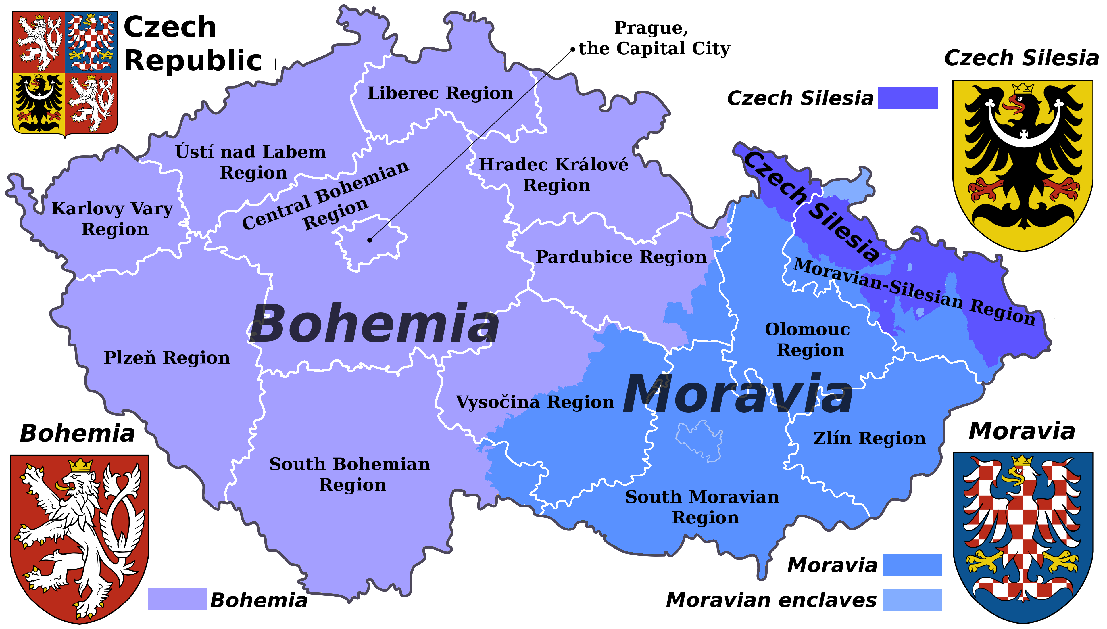
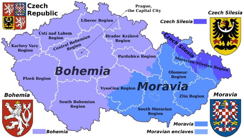
English: Map of the Czech republic showing the borders of its historical lands and the borders of the current administrative regions (kraje).
Čeština: Mapa České republiky s vyznačenými hranicemi krajů a historických zemí. |
| Date | (UTC) |
| Source | |
| Author |
|
| This is a retouched picture, which means that it has been digitally altered from its original version. Modifications: Translated to English. The original can be viewed here: Czech Rep. - Bohemia, Moravia and Silesia III.png:
|
I, the copyright holder of this work, hereby publish it under the following license:
This file is licensed under the Creative Commons Attribution-Share Alike 3.0 Unported license.
- You are free:
- to share – to copy, distribute and transmit the work
- to remix – to adapt the work
- Under the following conditions:
- attribution – You must give appropriate credit, provide a link to the license, and indicate if changes were made. You may do so in any reasonable manner, but not in any way that suggests the licensor endorses you or your use.
- share alike – If you remix, transform, or build upon the material, you must distribute your contributions under the same or compatible license as the original.
Original upload log
This image is a derivative work of the following images:
- File:Czech_Rep._-_Bohemia,_Moravia_and_Silesia_III.png licensed with Cc-by-sa-3.0
- 2011-08-07T15:52:18Z Millenium187 3852x2188 (1393382 Bytes) {{Information |Description={{cs|Moderní verze historického znaku Moravy.}} {{cs| Moderní verze historického znaku Slezska.}}{{pl| Współczesna wersja herbu Czeskiego Śląska.}} |Source=*[[:File:Czech_Rep._-_Bohemia,_Mor
Uploaded with derivativeFX
File history
Click on a date/time to view the file as it appeared at that time.
| Date/Time | Thumbnail | Dimensions | User | Comment | |
|---|---|---|---|---|---|
| current | 14:12, 19 March 2023 | | 3,852 × 2,188 (1.11 MB) | Moodylo333 | "Enclave" means: territory surrounded on '''all''' sides by the other territory |
File usage
There are no pages that link to this file.

.png)
.png&action=edit&redlink=1)
.png)
.png)