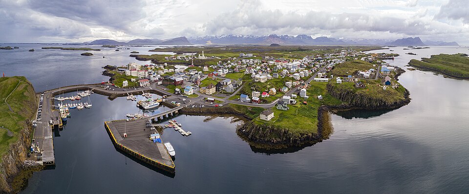
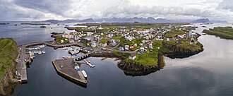
File:1 aerial pano stykkishólmur 2017.jpg
Jump to:
navigation
,
search

Size of this preview: 799 × 330 pixels. Other resolutions: 320 × 132 pixels | 11,652 × 4,813 pixels.
Original file (11,652 × 4,813 pixels, file size: 30.79 MB, MIME type: image/jpeg)
This file is from Wikimedia Commons and may be used by other projects. The description on its file description page there is shown below.
Summary
Description1 aerial pano stykkishólmur 2017.jpg |
English: stykkishólmur iceland |
Date | |
Source | Own work |
Author | Chensiyuan |
Camera location | 65° 04′ 46.86″ N, 22° 43′ 45.25″ W ![]() | View this and other nearby images on: OpenStreetMap | ![]() |
---|
Licensing
I, the copyright holder of this work, hereby publish it under the following license:


This file is licensed under the Creative Commons Attribution-Share Alike 4.0 International license.
- You are free:
- to share – to copy, distribute and transmit the work
- to remix – to adapt the work
- Under the following conditions:
- attribution – You must give appropriate credit, provide a link to the license, and indicate if changes were made. You may do so in any reasonable manner, but not in any way that suggests the licensor endorses you or your use.
- share alike – If you remix, transform, or build upon the material, you must distribute your contributions under the same or compatible license as the original.
Captions
Add a one-line explanation of what this file represents
Items portrayed in this file
depicts
21 June 2017
65°4'46.859"N, 22°43'45.253"W
image/jpeg
1300a62fd1747f55ae3b33a049ba3d5c65ac1406
32,283,208 byte
4,813 pixel
11,652 pixel
0.00833333333333333 second
6.3
200
8.8 millimetre
File history
Click on a date/time to view the file as it appeared at that time.
Date/Time | Thumbnail | Dimensions | User | Comment | |
---|---|---|---|---|---|
current | 03:59, 10 July 2017 | ![]() | 11,652 × 4,813 (30.79 MB) | Chensiyuan | User created page with UploadWizard |
File usage
The following page links to this file:
Metadata
This file contains additional information, probably added from the digital camera or scanner used to create or digitize it.
If the file has been modified from its original state, some details may not fully reflect the modified file.
Camera manufacturer | DJI |
---|---|
Camera model | FC6310 |
Exposure time | 1/120 sec (0.0083333333333333) |
F Number | f/6.3 |
ISO speed rating | 200 |
Date and time of data generation | 20:05, 21 June 2017 |
Lens focal length | 8.8 mm |
Latitude | 65° 4′ 46.86″ N |
Longitude | 22° 43′ 45.25″ W |
Altitude | 209.004 meters above sea level |
Orientation | Normal |
Horizontal resolution | 300 dpi |
Vertical resolution | 300 dpi |
Software used | Adobe Photoshop CC 2017 (Windows) |
File change date and time | 05:56, 22 June 2017 |
Exposure Program | Aperture priority |
Exif version | 2.3 |
Date and time of digitizing | 20:05, 21 June 2017 |
APEX shutter speed | 6.906891 |
APEX aperture | 5.310704 |
APEX exposure bias | 0 |
Maximum land aperture | 2.97 APEX (f/2.8) |
Subject distance | 0 meters |
Metering mode | Center weighted average |
Light source | Daylight |
Flash | Flash did not fire, No flash function |
DateTimeOriginal subseconds | 1 |
DateTimeDigitized subseconds | 1 |
Color space | Uncalibrated |
File source | Digital still camera |
Scene type | A directly photographed image |
Custom image processing | Normal process |
Exposure mode | Auto exposure |
White balance | Auto white balance |
Digital zoom ratio | 0 |
Focal length in 35 mm film | 24 mm |
Scene capture type | Standard |
Scene control | None |
Contrast | Hard |
Saturation | Normal |
Sharpness | Hard |
Subject distance range | Unknown |
GPS tag version | 0.0.3.2 |
Serial number of camera | 1ef71f8c9e228205c1ff8efd03eaacad |
Lens used | 24.0 mm |
Date metadata was last modified | 13:56, 22 June 2017 |
Rating (out of 5) | 0 |
Unique ID of original document | 8238F6EA6EFE0E0DF91C7A4BA74C8F99 |