File:Bristolparks.jpg

Size of this preview: 800 × 571 pixels. Other resolutions: 320 × 228 pixels | 2,010 × 1,434 pixels.
Original file (2,010 × 1,434 pixels, file size: 3.24 MB, MIME type: image/jpeg)
Summary
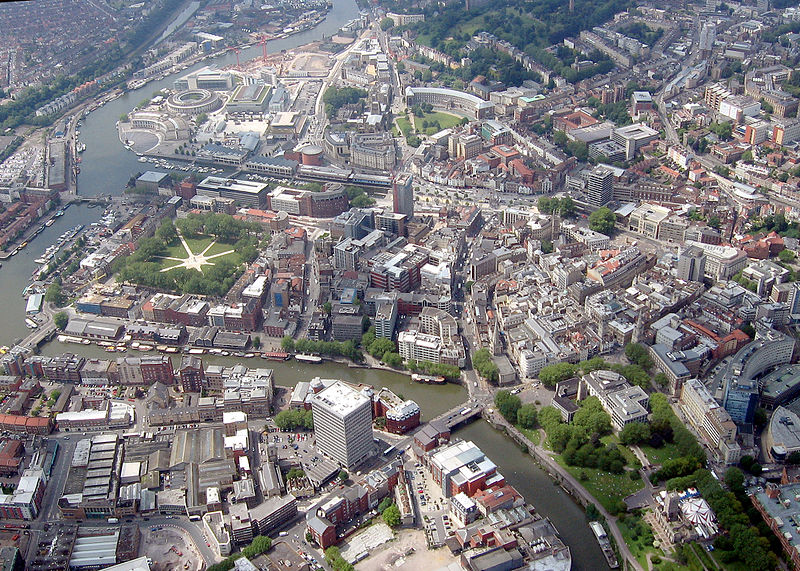
| Description | Aerial view of Bristol showing the principal parks in the centre. Brandon Hill(top right), College Green (above centre), Queen's Square (left), and Castle Park (bottom right). The waterway is the 'floating harbour'. |
| Date | |
| Source | Own work |
| Author | William Avery |
| Camera location | | View this and other nearby images on: OpenStreetMap |
|---|
Licensing
I, the copyright holder of this work, hereby publish it under the following licenses:

|
Permission is granted to copy, distribute and/or modify this document under the terms of the GNU Free Documentation License, Version 1.2 or any later version published by the Free Software Foundation; with no Invariant Sections, no Front-Cover Texts, and no Back-Cover Texts. A copy of the license is included in the section entitled GNU Free Documentation License. |
| This file is licensed under the Creative Commons Attribution-Share Alike 3.0 Unported license. | ||
| ||
| This licensing tag was added to this file as part of the GFDL licensing update. |
This file is licensed under the Creative Commons Attribution-Share Alike 2.5 Generic, 2.0 Generic and 1.0 Generic license.
- You are free:
- to share – to copy, distribute and transmit the work
- to remix – to adapt the work
- Under the following conditions:
- attribution – You must give appropriate credit, provide a link to the license, and indicate if changes were made. You may do so in any reasonable manner, but not in any way that suggests the licensor endorses you or your use.
- share alike – If you remix, transform, or build upon the material, you must distribute your contributions under the same or compatible license as the original.
You may select the license of your choice.
File history
Click on a date/time to view the file as it appeared at that time.
| Date/Time | Thumbnail | Dimensions | User | Comment | |
|---|---|---|---|---|---|
| current | 15:04, 17 February 2007 | | 2,010 × 1,434 (3.24 MB) | Arpingstone | Forgot to detilt it |
File usage
The following page links to this file:
