File:Suriname regions map.png

Size of this preview: 488 × 599 pixels. Other resolutions: 195 × 240 pixels | 1,999 × 2,453 pixels.
Original file (1,999 × 2,453 pixels, file size: 915 KB, MIME type: image/png)
Summary
| Description |
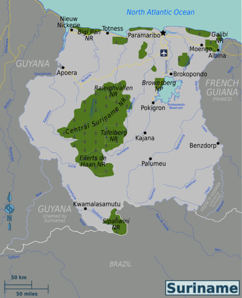
English: Map of Suriname. |
| Date | |
| Source | Own work based on Perry-Castañeda Library Map Collection - University of Texas Libraries |
| Author | Globe-trotter |
| Other versions | SVG base file, French, Russian |
Licensing
This file is licensed under the Creative Commons Attribution-Share Alike 4.0 International, 3.0 Unported, 2.5 Generic, 2.0 Generic and 1.0 Generic license.
- You are free:
- to share – to copy, distribute and transmit the work
- to remix – to adapt the work
- Under the following conditions:
- attribution – You must give appropriate credit, provide a link to the license, and indicate if changes were made. You may do so in any reasonable manner, but not in any way that suggests the licensor endorses you or your use.
- share alike – If you remix, transform, or build upon the material, you must distribute your contributions under the same or compatible license as the original.
Original upload log
| This file was imported from Wikivoyage WTS. |
The original description page was here. All following user names refer to wts.wikivoyage-old.
- 2010-01-15 04:31 (WT-shared) Globe-trotter[dead link] 971×1195 (241213 bytes) {{Imagecredit|credit=Globe-trotter|captureDate=January 15, 2009|location=Suriname|source=[Suriname_regions_map.svg http://wikitravel.org/sha (Import from wikitravel.org/shared)
- 2010-01-15 04:48 (WT-shared) Globe-trotter[dead link] 971×1195 (243302 bytes) small edits (Import from wikitravel.org/shared)
- 2010-01-15 04:54 (WT-shared) Globe-trotter[dead link] 971×1195 (207922 bytes) fixed some bug with a photo editing program (Import from wikitravel.org/shared)
- 2010-01-24 18:32 (WT-shared) Globe-trotter[dead link] 1626×2000 (812109 bytes) added rivers, a national park and disputed boundaries (Import from wikitravel.org/shared)
- 2011-08-11 05:49 (WT-shared) Joelf[dead link] 1619×1991 (807596 bytes) "Caluini" river -> "Cafuini" river (Import from wikitravel.org/shared)
- 2012-10-31 14:54 Globe-trotter[dead link] 434×533 (114402 bytes) removing regions, not necessary yet
- 2012-10-31 15:19 Globe-trotter[dead link] 434×533 (114548 bytes) added Suriname dot
- 2012-11-01 17:55 Globe-trotter[dead link] 434×533 (113316 bytes) fixed river
File history
Click on a date/time to view the file as it appeared at that time.
| Date/Time | Thumbnail | Dimensions | User | Comment | |
|---|---|---|---|---|---|
| current | 10:04, 5 September 2014 | | 1,999 × 2,453 (915 KB) | Globe-trotter | added nature reserves |
File usage
The following page links to this file:

.png)