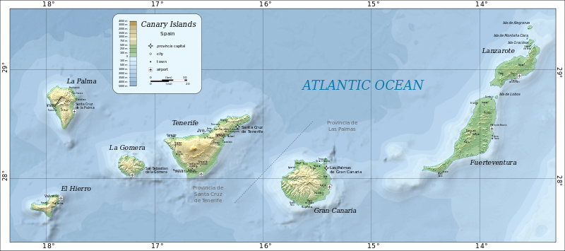
File:Map of the Canary Islands.svg

Size of this PNG preview of this SVG file: 800 × 355 pixels. Other resolution: 320 × 142 pixels.
Original file (SVG file, nominally 3,152 × 1,400 pixels, file size: 835 KB)
Summary
| Description |
Deutsch: Karte der Kanarischen Inseln auf Englisch English: Map of the Canary Islands. Magyar: A Kanári-szigetek térképe Română: Harta Insulelor Canare. |
| Date | |
| Source | Self-made in Inkscape by w:User:Mysid. Based on SRTM data as edited by CGIAR-CSI. Place names based on the Open Streetmap. |
| Author | Oona Räisänen (Mysid) |
| Other versions |
|


Licensing
| This work has been released into the public domain by its author, Mysid at English Wikipedia. This applies worldwide. In some countries this may not be legally possible; if so: Mysid grants anyone the right to use this work for any purpose, without any conditions, unless such conditions are required by law. |

|
This SVG file contains embedded text that can be translated into your language, using any capable SVG editor, text editor or the SVG Translate tool. For more information see: About translating SVG files. |
File history
Click on a date/time to view the file as it appeared at that time.
| Date/Time | Thumbnail | Dimensions | User | Comment | |
|---|---|---|---|---|---|
| current | 14:57, 26 June 2020 | | 3,152 × 1,400 (835 KB) | Gaja | fixed and supplemented place names, some error correction |
File usage
The following 2 pages link to this file:
