File:Czech-regions wts.png

Size of this preview: 771 × 600 pixels. Other resolutions: 309 × 240 pixels | 1,609 × 1,252 pixels.
Original file (1,609 × 1,252 pixels, file size: 744 KB, MIME type: image/png)
Summary
| Description |
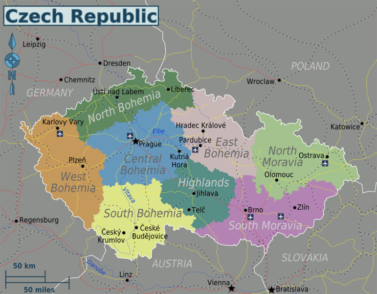
English: Map of the Czech Republic. |
| Date | |
| Source | Own work based on CZ-cleneni.svg (data origin: Tlusťa (public domain), edited by Miraceti (smoothing, colours, export to svg) and Al (corrected region description for C region)), Czech parliament elections 2006 - region_winners.svg by Frettie, and the Perry Castañeda Map Collection - University of Texas Library (public domain) |
| Author | Globe-trotter |
| Other versions | SVG base file, Russian |
Licensing
This file is licensed under the Creative Commons Attribution-Share Alike 4.0 International, 3.0 Unported, 2.5 Generic, 2.0 Generic and 1.0 Generic license.
- You are free:
- to share – to copy, distribute and transmit the work
- to remix – to adapt the work
- Under the following conditions:
- attribution – You must give appropriate credit, provide a link to the license, and indicate if changes were made. You may do so in any reasonable manner, but not in any way that suggests the licensor endorses you or your use.
- share alike – If you remix, transform, or build upon the material, you must distribute your contributions under the same or compatible license as the original.
Original upload log
| This file was imported from Wikivoyage WTS. |
The original description page was here. All following user names refer to wts.wikivoyage-old.
- 2009-09-15 01:57 (WT-shared) Globe-trotter[dead link] 2500×1569 (368811 bytes) {{Imagecredit|credit=Globe-trotter|captureDate=September 15, 2009|location=Czech Republic|source=[[http://wikitravel.org/shared/Image:czech- (Import from wikitravel.org/shared)
- 2009-09-15 02:06 (WT-shared) Globe-trotter[dead link] 2500×1569 (361809 bytes) {{Imagecredit|credit=Globe-trotter|captureDate=September 15, 2009|location=Czech Republic|source=Self-made|caption=SVG File Map of Czech Rep (Import from wikitravel.org/shared)
- 2009-12-28 04:19 (WT-shared) Globe-trotter[dead link] 1330×1037 (673420 bytes) {{Imagecredit|credit=Globe-trotter|captureDate=December 28, 2009|location=Czech Republic|source=[http://www.lib.utexas.edu/maps/czech_republ (Import from wikitravel.org/shared)
- 2010-01-01 19:06 (WT-shared) Globe-trotter[dead link] 1330×1037 (658849 bytes) changed railway lines into black dots, the black-white striped lines were too dominant (Import from wikitravel.org/shared)
- 2010-08-13 13:53 (WT-shared) Globe-trotter[dead link] 1608×1252 (757777 bytes) major overhaul; changed regions, changed colors, added cities, changed rails, added airports, changed font sizes, and more. (Import from wikitravel.org/shared)
- 2010-08-13 16:02 (WT-shared) Globe-trotter[dead link] 1608×1252 (765525 bytes) Added Highlands region (as it is in BOTH Moravia and Bohemia, and South Moravia was already rather crowded, so an extra region wouldn't hurt (Import from wikitravel.org/shared)
- 2012-11-01 15:54 Globe-trotter[dead link] 1609×1252 (761443 bytes) optimization
File history
Click on a date/time to view the file as it appeared at that time.
| Date/Time | Thumbnail | Dimensions | User | Comment | |
|---|---|---|---|---|---|
| current | 17:41, 20 November 2012 | | 1,609 × 1,252 (744 KB) | OgreBot | (BOT): Reverting to most recent version before archival |
File usage
The following page links to this file:
